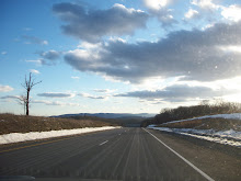
When we got food at a Subway in a gas station in Luray, we decided not to eat it there, but instead up on Skyline Drive in an overlook. After all, why not eat where there's a magnificent view? So we went up to Skyline Drive, on a road full of tight, ascending hairpin turns. We finally got up to the top, went through the gate and got the map for Skyline Drive. (I had done research enough to know where it began and ended, but not all the overlooks). The guide asked if we were doing any hiking, hoping that he didn't have to deal with us planning to traipse for days in the snow. We said that we didn't need hiking maps, just driving through sir, and went on our way.
 As soon as you turn onto Skyline Drive at Thornton Gap, you go up and through the Mary's Rock tunnel, which is an interesting way to begin a drive. We made it through and got to the first overlook, the Tunnel Parking Overlook. We got our first view of a Shenandoah overlook- a majestic panorama of mountains which drop to plains beneath. We parked the car along the curb, and Bethany insisted on eating outside (I was being a wimp due to sub-freezing temperatures and my inability to eat food with mittens). We sat on the little rock wall and ate half of our subs (one great thing about eating footlong subs on roadtrips- two small meals spaced out!). If you blow up the picture, you can see that there's a small ridge with some dead grass, then a cliff down the mountain, which then rises to other peaks in the distance. Truly beautiful. Also, truly cold. After eating and snapping some pictures, I was cold, so ran in the car. Bethany, even with worse circulation, was quite fine.
 The next overlook, Hazel Mountain, was even further up, at around 2700 feet (the maps and signs at the overlooks make sure to tell you the elevation, a nice touch). This had a slightly wider ridge where you could go down even closer to the cliff. I went down and posed for the picture. What you can't see is that both my legs are in about a foot of snow. Ay, the price of vanity, but yea, the glory of car heating.
Apparently, along Skyline Drive there are nearly 100 scenic overlooks, almost one a mile. Moreover, as I looked on the map, I noticed that the middle section had by far the highest elevations, with nearly every point between the two gaps over 3,000 feet. I had figured that this section was the easiest to plow, and therefore the blandest; instead, its views were the most majestic, with Old Rag acting as a focal point to the east and the Massanutten Mountains rising past the valley on our west. I was quite impressed with the Shenandoah staff, plowing the most difficult yet most beautiful sections of the park. Of course, this section is probably the most popular, but I was truly impressed.
 We stopped off at a great deal of overlooks along the way, especially early on. The photo to the left is (I think) from the third overlook we stopped at, the Pinnacles Overlook, now 3,320 feet up. Behind us to the right (where the ridge slopes up) is Pinnacle Peak, and to the left would be Old Rag, a peak whose top is apparently one of the most beautiful ascents in the park, and one I hope to do if (as I'm hoping) I'll be spending some time in DC next year. Behind us is a nice informational plaque about Old Rag, very neat, clean, and direct. While at this overlook, we met an older local couple who were trying out the husband's new Christmas present, his badass Canon zoom lens camera thingy. They were taking advantage of the opening and the winter weather to try and snap some pictures of the abundant wildlife in the park, and he nicely took our picture for us with our camera, which was Bethany's Christmas present. Although I like the program I'm in, Long Island is both hectic and kinda ornery, and it was most pleasant to be someplace nice and relaxed.
 Because Skyline Drive is on a mountain ridge, overlooks abound on both sides, to the east and west. The first few we stopped at were all east facing. We took advantage of a few overlooks on the otherside. This picture is from either the Stony Man or Little Stony Man overlook. Whichever overlook it was had a paved area with small rock wall, and then a small plain that ends in a cliff into the valley. Intrepid Bethany walked over the icy snow to the edge, and I snapped her picture. Notice the difference in this view than the previous ones- rather than a view of mountains with plains deep in the background, this shows a rather sudden valley with a seemingly endless river of mountains behind it. Although the camera could not pick it up, we could see Luray and the route we took up through the overlook. Quite fascinating, how below we were enchanted by the beautiful mountains on our sides, and now looking back on whence we came. I think this picture shows the enormity of the landscape and vastness of the hills, something which awes you if you've spent most of your life on sand bars on the Atlantic. Because it's a winter picture and there's no trees, you really see the enormity of pure mineral, pure rock. That's the wonderful thing with these overlooks- each season will have something to offer, whether the verdant blooms of summer, the changing leaves of late fall, or the naked beauty and calm of winter.
By this point, we had gotten to be overlook pros, so we were no longer stopping at every one (and sometimes we needed to be in the car a couple of miles to warm back up). We passed by Skyland and reached the highest point on the drive, almost 3,700 feet up. We decided to stop at Crescent Rock (elevation over 3500), which faces westward. At first it looked like a regular overlook, with a small parking area and a wonderful view. We got out and saw a plaque indicating that there was a path to an even better view about 100 yards to the left off the main parking area. Now, of course, snow covered the ground, but I ran over to the left and saw the short path to a ledge which we could see from the parking lot. Figuring it wasn't too far, we headed over. Poor Bethany had forgotten her boots, so she gingerly stepped through the snow and ice, while I tried to stomp down so she could literally follow in my footsteps. The path had been stamped down- even though the park had been open no more than 48 hours, already people had come up and down. We finally made it to the ledge, and it truly was an awesome sight. Moreover, we were insulated from the road. Now, the only noises we heard despite the long, echoing valley were ourselves and, occasionally, a cheerful cry from a child hiking with his family in the paths below the overlook. We were wonderfully, beautifully alone.

 This view deserves two pictures to show the full breadth of its grandeur. The ledge, called Crescent Rock, protrudes out, allowing multiple different vantage points. The first picture is the view looking left from the rock. The peak to the right of Bethany is Hawksbill Mountain, the highest peak in the park at over 4100 feet. Because it's winter, you really get a sense of the topography of the mountain, which splays down to the valley below. Looking straight, you would see the slopes of Hawksbill and the cliff below coming to a point, then a valley behind. The second photo, taken by Bethany, is looking to the right directly on the rock. Although they kinda look like it, the pictures don't combine to produce a panorama, although the background hill does come off of Hawksbill. The overlook that we are on (the rock is protruding out), combined with Hawksbill, form the top of this northwest-flowing valley which pours out into the other valley behind it. Then, you can see the Mannahasset mountains rising in back.
  The last stop of note is Big Meadows, which as the name implies, is not an overlook but rather an unexpectedly vast plain about 3500 feet up. We parked and saw the plain overrun with deer! We hadn't seen any wildlife yet (which is probably a good thing given the hilly nature of Skyline- no need to stop suddenly for a deer on a steep descent), and Bethany wanted to take a few pictures. Since deer are relatively docile animals, you can walk up fairly close to them. We, and a few other people, got out of the car and walked into the meadows. (Our friends who took our picture earlier rolled up and were perfectly content to use the zoom lens from the warmth of their truck than get out). Off the parking area was a paved path that bisected the over mile-long meadow, leading to a camping area. The deer were concentrated directly to the right, grazing on one of the few areas with relatively exposed grass. Bethany walked toward the herd (I stayed back for most, then came up), getting quite close to the herd and snapping a few pictures of them grazing like this one. It's hard to believe that the Crescent Rock view and the vast plains of Big Meadows are no more than five miles away, which shows the concentrated diversity and natural beauty found in the park.
 Having spent about 2-3 hours stopping at various overlooks for about 20 miles, we were content to head out. We stopped at one more a few miles up to have the other half of our subs, then we went toward the south point of our journey. The few miles north of Swift Run gap seem to know that the northbound driver has been satiated with natural wonder, and so it zooms by relatively quickly and unobtrusively (although my brakes might beg to differ). We got to the gap, exited (and saw the barricade with the road sort of plowed on the other side), and began our descent down from the mountains on US 33. I was careful to pump and cool my brakes so that we'd make it down as smoothly as possible. We got some more downward hairpin turns, and eventually made it down the other side. Bethany had fallen asleep, and so I made the decision to stay on US 33 until I saw a sign for I-64, which roughly paralleled the road to the south. Both roads would end up in Richmond, so I figured at some point there would be a way to hop on the interstate. On the map, it showed that US 29 went down, but it doubled back slightly west and went through Charlottesville, and I figured there would be a more direct way. US 33 was a pleasant, divided highway for a while, but after the US 29 intersection it was slow and meandery, feeling more like a state route. We ran into a downtown (Gordonsville), and I hoped that we'd hit a turnoff sometime soon. Fortunately, the other side of town was good ol' US 15 (which we had left in Maryland), with a nice "To I-64" sign. We took a right, and about 12 miles later we reached I-64. Bethany took over, and we did the last two hours to Williamsburg.
We made it to our motel around 7 or so, and were a little creeped out that we were the only guests in our section of the building (it was, after all, a Wednesday night in the offseason at a cheapo motel). However, our room had functioning heat which did not require insulation via comforter, and we were within walking distance of what seemed like a good local breakfast joint, so we were pleased. After unpacking and showering, we decided to go out on the town. Unfortunately, from general relaxing and a little bit of cluelessness about how Williamsburg was laid out, we didn't get into town until after 9, by which time everything was closed. We resigned ourselves to a dinner of Clif bars, but we knew that we'd have good breakfast in the morning. And, AND, most importantly, we wouldn't have to drive out of town.
No comments:
Post a Comment