
BEGINNING: Gettysburg, PA
END: Front Royal, VA
STOPPING IN: Emmittsburg, MD; Cunningham Falls State Park, MD; Berkeley Springs, WV
ROUTE: US-30 to PA-97 to Gettysburg Auto Road to US-15 to MD-77 to MD-64 to MD-66 to I-70 to US-522 to US-340
(If you want to start from the beginning, go to the next post and read up.)
Planning is a funny thing. It's bad to plan everything along your route, but it's good to do a lot of planning in order to know where things are, what routes are possible, and where to go in order to maximize the possibilities for doing stuff. This day was the least planned, other than our appointment at the Berkeley Springs State Park. It's also the part of the trip that I knew the least about, having only passed through this area on I-81. Because of this, I looked online and on the map route to figure out the best way to go, what else is on that route, and where to end up.
However, to do stuff, well, you have to get up and do it. We were up and out before 8 despite the freezing, freezing cold. We drove through Gettysburg and south to the Gettysburg National Military Park. The closest section to downtown is the National Cemetery, so we went there first. We were, shockingly, the only people who decided on a sub-freezing Tuesday at 8:30 AM to visit the cemetery, so we had it all to ourselves. Like Arlington, it is a very simple yet moving construction. There is a large statue where Lincoln stood, and the semicircle surrounding it are wedges of killed Union soldiers organized by state, with prominent UNKNOWN sections on either edge, impossible to miss (and drastically larger than the others). Although there was snow on the ground, the graves were reverently shoveled off. It also points the dead exactly toward where Lincoln gave his address, giving a fairly complex relationship between leadership and the dead. The other side is a cemetery that is barred off (from our side, at least), and it is surrounded by various statues and graves of other deceased soldiers and veterans.
One criticism is that you become very aware that it was HERE that Lincoln gave the Gettysburg Address. The first monument you see when you walk up the path, which maps out the cemetery and gives the full text of the Gettysburg Address. At this point, the monument's simple white text on black background allows the somber, yet eloquent poetry of the statement to come through. Yet, every single placard that you see paraphrases it until the phrases become cliche. The Gettysburg Address, at least in my opinion, is beautiful because it is short, sweet, and moving. Taking and reposting chunks banalizes, rather than beatifies, it.
We then went to the visitor's center and picked up a map for the Auto Road. The Gettysburg Auto Road maps out a route for autos so you can drive on the various sites of the battlefield. It's also numbered in chronological order so the driver can follow the progression of the battle. The road is in red on the link. You can see that it's quite long, and since we only had maybe an hour, we just went to the section we were near, the southeast quadrant. We went to stops 13 & 14 (Spangler's Spring and Cemetery Hill), and Culp's Hill. The fascinating part of this trip is not only the various plaques that tell you what happened there. Instead, the whole area is littered with old stone statues to mark the many divisions and battalions which fought there. These seem to be placed in the decades right after the war far before the idea of making the area a National Military Park. Thus, not only do you see tons of statues along the route, but also on the many hiking paths. Since it was very cold, we didn't walk far, but we took a small path just off Culp's Hill, and we saw at least 4 or 5 nowhere near where a driver would see it. It makes for a very serious emotional moment knowing that the way you are directed, even through the National Park system, may not accurately reflect the complex cartographies of history.
We then headed south on US 15, crossing into Maryland at Emmittsburg. On the highway, we saw signs for the Elizabeth Ann Seton shrine. Bethany, being Catholic, wanted to see the shrine for the first U.S.-born saint. We got there just before it opened, waited in the car about 10 minutes, and then went into the basilica. It was a lovely church and a simple shrine on the side, with a good visitor's center, a cheesy gift shop, and some nuns trotting about.
 We left and went south on US 15. About 4 miles from where we turn west onto some Maryland state routes to get towards Berkeley Springs was Cunningham Falls State Park. I had noticed it on Google Maps (which is one of many reasons that Google Maps is fantastic) and when I looked it up, I saw that the path to the falls was less than half a mile and handicapped accessible. So even though the ground was snowy and icy, we hiked up to the falls. That's me, and you can see the falls in the background. Considering the last trip Bethany and I took was all outdoors, it was important that we did some hiking even if the weather was not cooperating. This was also the first place we turned on the new camera which was Bethany's Christmas present (so there's pictures here on in!)
  We meandered west on I-70 until we went south on US 522. Maryland is at its thinnest there- the US 522 exit was one mile before I-70 went north into Pennsylvania. We got off the exit, went about a mile south, and were already in West Virginia. Six miles up is Berkeley Springs, and right downtown is the Berkeley Springs State Park. Berkeley Springs has natural hot springs which have been used for time immemorial, and the center square has been a public spa since the town was incorporated in the mid-18th century. Mineral water is pumped into different tubs- George Washington's tub was memorialized, as you can see if you click on the picture to the left. The state park is a spa with mineral baths and massages on what essentially is a village green. Bethany and I scheduled a 15 minute bath, and we were very nicely given almost 40! The water was supposed to be at 102 degrees, and although it was a little colder owing to the fact that we had the first bath after lunch break, the water was clean, pure, and wonderful to soak in. We then had 30-minute Swedish-style massages at 2. Mine was quite nice, especially on my arms and lower legs. Bethany was less pleased with hers (since state park employees are paid by the state, good masseuses are likely going to work in one of the many private spas around), but she does like her massages painful. We then warmed up and lazed out in a coffeehouse next door before getting back on the road.
 We decided to go to Front Royal, about 60 miles straight down US 522. Front Royal was more of a strategic location than a particular destination. It is the top of Skyline Drive, it allows for travel in the Shenandoah Valley to Luray Caverns via US 340, or if the weather was crappy, we could head east on I-66 and get to Williamsburg (where we were due in Wednesday night) in about 3.5 hours. And, as we discovered via billboards on the way down, there were the Skyline Caverns in Front Royal as well. US 522 enters Virginia at about its northernmost point, and rolls along the hills down into Winchester. It's really quite a beautiful ride through forests and hills brushed with snow, and we took some pictures, one of which you can see to the left. We followed 522 through Winchester and made it down to Front Royal. We stayed in a hotel so sketchy, we actually drove to a Papa John's rather than having the pizza delivered. However, it was only about a mile away from the Skyline Caverns, so we sucked it up and fell asleep. However, we may in the future just spend the extra $20 so that we, say, don't have to use the comforter to block the doorway so the 20-degree air doesn't come in. It wasn't an ideal destination, but it set up a lot of possibilities for the next day and allowed us to enjoy our massages, baths, and look at the new pictures.
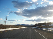
No comments:
Post a Comment