BEGINNING: Williamsburg, VA
END: Long Island via Outerbridge Crossing
STOPPING IN: Jamestown, VA; Rehoboth Beach, DE
ROUTE: VA 31 to VA 199 to I-64 to US 13 to US 113 to DE 24 to DE 1 to Cape May Ferry to US 9 to Garden State Pkwy to NJ 440
Unfortunately, all good trips must come to an end, especially when your traveling partner has work Sunday morning. So we hitched Rita up one last time and drove off from Williamsburg. However, I didn't want to go back the most direct way, which is to hop back on I-95. I've done that ride a whole lot of times already, and since it was our last day, ending the trip with memories of sitting in traffic on the DC beltway was not my cup of tea. Plus, being in Williamsburg opened up a way back almost completely consisting of new roads for me- down to Virginia Beach, up US 13, and to the Garden State Parkway over the Cape May ferry. I managed to convince Bethany to go this way by selling its newness and lack of traffic while softpedaling the approximate time it would take to get there (about 8.5 hours, says Google Maps).
On the way out, we also quickly stopped in Jamestown to see if there was anything to quickly view. We got there around 8:30, noticed that the only things to see were behind a Visitor's Center which wasn't open and charged money for admission, and turned around. We did go to the ruins of a Glasshouse, the foundation of a 1608 building set right on the water. We also, according to Bethany, saw where Captain John Smith fell in love with Pocahontas at about five different locations. It was pretty, even if we mostly struck out in the attractions department.
We then headed west into the Hampton Roads area on I-64 to get to the Chesapeake Bay Bridge-Tunnel. Bridge-tunnels are pretty unique- there are eight in the world, and the only three in the US are all in Eastern Virginia. So on the way to the Chesapeake Bay Bridge-Tunnel, we got the Hampton Roads Bridge-Tunnel. This was fascinating to drive on- it feels as if you're driving on the water, and ahead of you it seems like the road disappears and you go under into a tunnel. However, with the Hampton Roads Bridge-Tunnel, you always see land ahead of you. Not so with the Chesapeake Bay bridge.
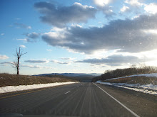
 We exited I-64 for US 13 and headed onto the Chesapeake Bay Bridge-Tunnel. The bridge is about 23 miles long, and after the first couple of miles, you stop seeing any land whatsoever. Here you feel not just like you're over a river, but driving on the ocean, where your scenery is the occasional naval boat. A picture of the "scenery" about 15 miles in is on the left. The road had a gentle right-ward bend, and twice disappeared into the water down into the tunnel. I very much enjoy driving on roads that are also engineering marvels (see Skyline Drive earlier in this trip, or previously going on US 1 or through the Eisenhower Tunnel on I-70), and I thoroughly enjoyed being on this impressive road.
  We finally made it to the other side, stopping at an overlook which was freezing and windy, and then traveled the long haul through the Delmarva Peninsula. This part of Virginia was a lot longer than I anticipated, with about 80 miles until the Maryland border, but it was a very easy ride- no traffic, only an occasional traffic light, just a lot of land with not a whole lot on it. It was very much stress-free, which is more than you can say for I-95. Once we got to Maryland, I took the fork for US 113, effectively deciding that we were going over the Cape May ferry rather than up to the NJ Turnpike. In preparation for possibly going this way back, I knew the ferry schedule (it's pretty annoying to get to a ferry and then find out the next one is in an hour). We meandered through middle of nowhere Maryland and Delaware before ending up at the Rehoboth Mall outlets area. Once we found out we were only 10 minutes away from the ferry terminal at that point and had over an hour, we took advantage of the tax-free shopping for a bit. We hightailed it to the ferry to make the 2:45.
The ferry...well, I'm sure it's a fine ferry normally, but we got a day with a wind advisory, notice that the trip would take longer than normal, and warning to always hold the railings if you had to move around. We got one and a half hours of pure rocking. I'm used to the Long Island Sound ferries, which don't really go over exposed seas. This ferry crosses over 17 miles at the mouth of the Delaware River, making for some rocky seas. I've never seen Bethany so focused on a card game (in order to trick herself into not being seasick). Hell, I even felt a bit seasick, and I'm from Cape Cod! After one last jerk at the ferry dock threatened our innards, we eagerly got the hell off of the ferry. It was nice to try it once, but we decided this was probably our last trip on the Cape May-Lewes Ferry.
The rest of our trip was a slow realization that we were getting back into the New York metro area. The bottom of the Garden State Parkway was alternately beautiful (views to the right of beach spits surrounded by marsh and ocean) and annoying (really? traffic lights?). We eventually got back into the city, made it through (Bethany was at the wheel, making her first trek across the city), and were welcomed by roads barely plowed from the night before. We made it back, thoroughly exhausted, and with a mix of happiness to be back and sadness that the trip was over.
************************************
It's been now just over two weeks since we returned to Long Island. Bethany is home in Michigan for a few more days, and I've been teaching and writing grant proposals, which explains the delay in getting the whole trip up. It's been fun to document the trip (though it is easier to do it right after, when the iron is hot- see my previous posts for smoother, more intimate memories). Part of me wishes the trip could have been longer, but it was a wonderful length. There was a good balance of driving and being in places, we had a week jam-packed with new experiences and new places with great memories. And, most importantly, I had good company. It's wonderful having a very easy-going driving and riding partner who is really gung-ho, positive, and goes along with my crazy schemes.
So, where next? For a while, nowhere. I've consigned myself to working my butt off for the next two months here on Long Island. March and April are lining up to be chock-full of travel and excitement, though. And, of course, I'll still be checking in here from time to time. However, it is a nice day above freezing, and so I'm off on a nice bike ride.